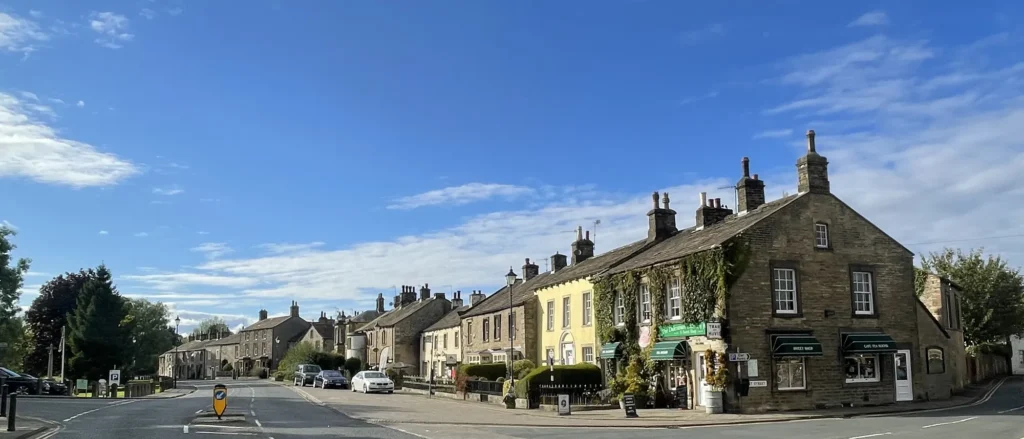
Gargrave is one of those rare Dales villages that works brilliantly without a car. You’ve got a train station, the Leeds & Liverpool Canal running right through, and the Pennine Way passing the village edge — making it a favourite base for walkers, cyclists and weekend escapees.
Where to stay: Gargrave has a good mix of cosy B&Bs, pub rooms and self-catering cottages — ideal if you want a relaxing base that still puts you on the doorstep of the Dales. Check availability in Gargrave and you’ll see what’s best for your dates.
Most visitors come for the simple formula: easy access + big scenery. Spend your days on canal-side strolls or longer Dales hikes, then be back in time for a pub supper. If you’re planning to explore further afield, Skipton is close enough for markets and castle days, while Bolton Abbey and the steam railway make an easy outing.
Where To Stay Near Gargrave

Lock View
Best for: canal-side base with easy walks straight from the door.
- Great for Pennine Way walkers
- Easy access to the canal towpath
- Ideal for Skipton day trips
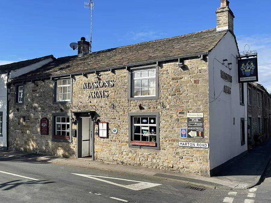
The Masons Arms
Best for: Family rooms and dog-friendly
- Ideal for Skipton day trips
- Great for Pennine Way walkers
- Home cooked meals

The Old Swan
Best for: perfect stop off during hike or bike ride
- Dog and child-friendly
- Quiet location
- Bike racks
With a population of barely 1,700, the village is small and quaint, making it an ideal place for a relaxing break as well as an outdoor adventure. Much of its architecture is Victorian and is constructed using traditional Yorkshire stone. Despite its diminutive size, Gargrave is home to number of public houses, some of which double up as bed and breakfasts.
Hikers and cyclists are common visitors to this part of North Yorkshire and it’s easy to see why. The Pennine Way National Trail, which runs for 267 miles from Kirk Yetholm on the Scottish border to Edale in Peak District, cuts directly through Gargrave. Walking the Pennine Way? Book a Gargrave base with breakfast + drying room.
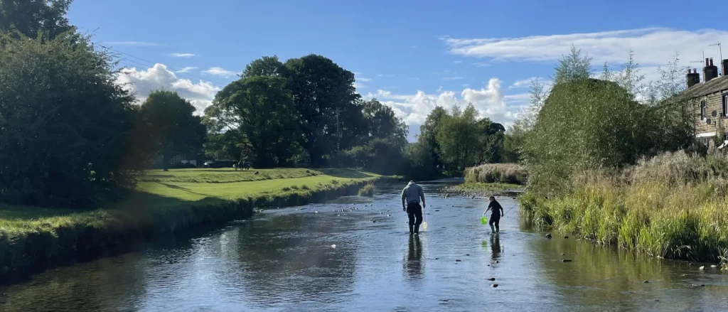
The village also sits on the Leeds and Liverpool Canal. Built between 1770 and 1816, the canal was once an important system for the movement of cargo between Yorkshire’s mill towns and the docks on Merseyside. Today it provides a beautiful and tranquil place to walk. Canal-side stays in Gargrave.
Without question, Gargrave provides a fantastic base for those looking to spread their wings a little further afield, with the medieval Skipton Castle being a popular destination for history buffs. More information on Skipton as a base for Yorkshire Dales trips.
View Gargrave accommodation on the map
Use the map to compare live stays and prices — click a price pin to book.
Visitors should also check out the Embsay and Bolton Abbey Steam Railway. Opened in 1888, the line runs over four miles from a station close to the 12th century ruins of Bolton Abbey through the villages of Draughton and Holywell before ending in Embsay. Stay in Gargrave, day-trip to Skipton.
Other Yorkshire Dales Towns to Consider
If you’re exploring different bases for your trip, you may also want to consider Skipton, a lively market town and popular gateway to the western Yorkshire Dales. Skipton travel guide & places to stay
Parking and Transport to Gargrave
Gargrave is easy to reach whether you’re arriving by train, car or on foot. The village has its own railway station on Church Street (a short walk to the centre), with services operated by Northern. If you’re coming by car, Gargrave sits on the A65, around four miles north-west of Skipton, so it works well for a weekend base with quick access to the wider Dales. For parking, many visitors use North Street Car Park (handy for the village and the canal), then explore on foot from there. Once you’re in Gargrave, the Leeds & Liverpool Canal towpath makes an easy, traffic-free route for strolls (including the popular walk towards Skipton), and the Pennine Way crosses the canal at Higherland Lock.
Car-free weekend idea
Arrive into Gargrave by train, drop your bags, then do a relaxed first walk along the Leeds & Liverpool Canal towpath before settling in for dinner at one of the village pubs. The next day, follow a section of the Pennine Way from Gargrave for a proper Dales walk, then finish with a late lunch back in the village. If you’re making a weekend of it, it’s worth booking accommodation within easy walking distance of the station and the canal so you can do everything on foot
Perhaps the first person to bring national notoriety to Gargrave was the poet Robert Story. Originally from Northumberland, he moved to the region in 1820 and penned some of his most famous works, including Craven Blossoms, Magic Fountain and The Outlaw, while looking out across the local scenery.
Gargrave enjoyed further attention during the 1960s when the remains of a Roman Villa known as Kirk Sink were found in the village. The dig, which was led by a team from the Archaeology Department at the University of Leeds and The Friends of Craven Museum, uncovered the foundations of a property built between the second and fourth centuries.
A number of the artefacts recovered can be viewed at the Craven Museum and Gallery in the town of Skipton, which is approximately four miles south of Gargrave.
FAQs
Absolutely. Gargrave is a classic “walk-from-the-door” base: the Pennine Way crosses the Leeds & Liverpool Canal at Higherland Lock in Gargrave, and there are easy circular options that mix fields with canal towpath walking.
If you want something straightforward, the Pennine Way’s own “Gargrave Ramble” is designed as an easier day walk, and you can also follow the towpath towards Skipton for a very gentle option.
Yes — Gargrave is one of the more practical Dales villages for a car-free break because it has a railway station a short walk from the village, plus you can do plenty on foot once you arrive (canal towpath and waymarked walks).
Train services run between Gargrave and nearby hubs like Skipton/Leeds (check times for your day).
For a straightforward option, there is a village car park on North Street that’s commonly used by visitors (it’s close to the centre).
Beyond that, Gargrave can be busy at peak times, so it’s best to:
- if you’re staying overnight, prioritise accommodation that offers dedicated parking.
- follow local signage for any time limits/restrictions, and
It depends what you want from the trip:
- Spring (Mar–May): greener landscapes returning and comfortable walking weather
- Summer (Jun–Aug): longest days and busiest village atmosphere (also the priciest for stays)
- Autumn (Sep–Nov): quieter paths and great colours
- Winter (Dec–Feb): crisp towpath walks and fewer crowds, but shorter daylight and more chance of wet/icy conditions
If you’re coming for walking, shoulder season (spring/autumn) is often the sweet spot.
Generally, yes — the canal towpath and many local walks make Gargrave very dog-friendly for a break.
For accommodation, always check the exact property policy (fees, number of dogs, rules on furniture/left alone).
If you’re bringing a dog, choose a stay with easy access to the canal towpath or countryside walks.